Saturday, September 13, 2014
Thursday, May 30, 2013
Back at Shining Rock Wilderness Area (Black Balsam Knob to Shining Rock Gap)
Its been a few months since I hiked to Shining Rock and had so much fun doing it, I decided to plan another hike for memorial day. I looked at many sites and decided on Black Balsam Knob as a starting point.

Black Balsam Knob, also known as Black Balsam Bald, is in the Pisgah National Forest southwest of Asheville, North Carolina, near milepost 420 on the Blue Ridge Parkway.
It is the second highest mountain in the Great Balsam Mountains. The Great Balsams are within the Blue Ridge Mountains, which are part of the Appalachian Mountains. It is the 23rd highest of the 40 mountains in North Carolina over 6000 feet.
The top of the mountain is a grassy bald that affords a panoramic view. The origin of grassy balds in southern Haywood county is a result of extensive clear-cut logging and locomotive fires in 1925 and 1942. These fires burned deep down into the mineral-rich topsoil slowing reforestation or stopping it altogether. Examples of this cannot only be found on Black Balsam knob, but many of its neighboring peaks and ridges. These unique features contribute greatly to the area's popularity, but the heavy amount of foot traffic also does further damage to this already fragile ecosystem.
The Art Loeb Trail follows the grassy ridge of Black Balsam Knob.
I invited a few friends along on this hike. It was me, Brooke and Joe. We left Kannapolis at around 9:15 am after having a nice breakfast at Cracker Barrel in Concord. We arrived at the trailhead at around 12:30 pm and started our adventure.
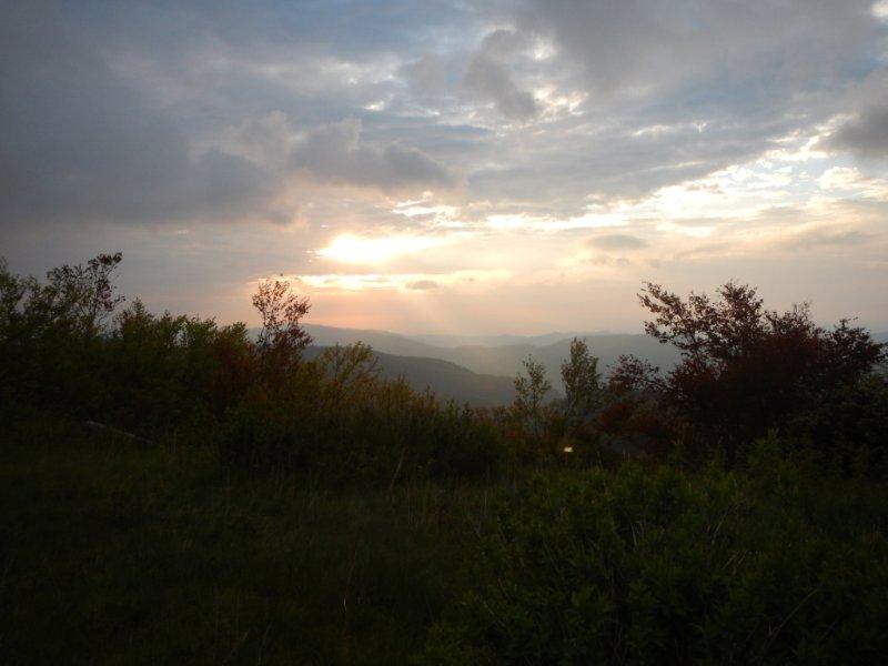
The first half of this section of the Art Loeb Trail is perhaps the most spectacular. The trail crosses over Black Balsam and Tennant Mountains, both exceeding 6,000 feet in elevation. At Black Balsam, the trail's highest point (at 6214 feet), is a plaque commemorating Art Loeb.Beyond Black Balsam the trail crosses into the Shining Rock Wilderness and passes over several mountain balds, including Shining Rock itself. This section of the Art Loeb Trail ends at Deep Gap and the intersection with the Cold Mountain Trail.
We made a turn off of the Art Loeb trail somewhere around Tennant Mountain and then again at the divide into the Shining Rock Wilderness area. None of the trails are marked very well, if at all. Many of these trails are either false, lead to random camp sites, or lead to another location along the main trails. Most will eventually lead to your destination, but might not be the fastest or shortest route. That last sentence perfectly describes our first day in the Pisgah National Forest and Shining Rock Wilderness Area. I had a 5.85 mile hike planned. We ended up hiking approximately 12-15 miles the first day. We touched sections of the Art Loeb, Little East Fork, and several others.. We approached Shining Rock from the North, despite starting from the South. It was a long day, but we saw many beautiful views. I came up with a new trail name for Brooke: "Flash." At one point she drove hard for about 3 miles or more and didn't let up. I was in the back and hoping not to get left behind. So, I hiked a super awesome, super long first day with Flash and Joe.


We made it to camp by around 6:30 pm, as I recall. We picked out our camp site in Shining Rock Gap and set up our tents. I made a stop for water from the creek on the way to camp so I started cooking some dehydrated chicken and rice. I ate all that I could and shared the rest. Flash and Joe were grateful for the food as they packed pretty lightly in that department. I bet I'll see more next time.. We ate and they went quiet. I didn't mention earlier, they were up all night before our hike and only slept for about 2 hours on the way to the Blue Ridge Parkway. I think they did amazing for someone who slept all night, and were phenomenal for someone who hadn't -- Way to go you two!
I'd like to say we slept all night without interruption, but that wouldn't be true. The last thing I did before going to bed was hang our food along with another group from Texas. In the wilderness area there are bears and other predators which will steal your food if its not secured. The guy from the other camp was already tossing a rope, so I hung our bag on his (with his permission). It was about 3:45 am when I heard something outside my tent. Shortly after that I heard the bags come out of the tree and hit the ground. At about 4am I got my shoes on and headlamp on and walked around that side of camp. I immediately noticed the bags were gone. I started searching the area and found our bag laying about 20 feet to the east in the woods. I looked, but never found the neighboring campers bag... I went back to bed and in the morning the other campers showed me what was left of their food and bag. It was torn to shreds... A bear definitely got our bags down and thankfully for me, a bear only has one mouth to carry a bag. I felt bad for the other backpackers, but found out after a long conversation in their camp that morning, they had other food stored in a bear canister. I think I will bring mine along next time. It will be good practice for Yosemite this August.
I boiled some water in my jet boil and made some oatmeal. After I ate I got my stuff packed up and tent packed in my pack. I was able to relax for a bit before the others got up and going. Considering our first day I was more than happy to let the others sleep in. They got up and had some breakfast and we chatted while they packed their tent up. All of us had some pretty good sun burn. I wasn't as bad as the others, but I wore a full shirt with sleeves. We hit the trail around 9am.
After going off course the day before we were all very observant of the trails we selected. We found quite a few markers for the Art Loeb trail, which we never saw the day before. And were happy to find a few short cuts that made the day a little easier. We saw two snakes on the trail. One was a grey rat snake (I think) and the other was a stripped garter snake. We made our way to the edge of the Wilderness area and found where we went off course the day before. From that point on, it was all back tracking.

We were happy to make the car, and I was happy no bears tried to get in to eat some multi-berry pancakes I left in the trunk.. I know, not supposed to do that..
We started on our drive home and decided that nothing would do except Red Robin to nourish us... So I made my way to Charlotte where we ate at Red Robin. We headed back to my house and from there Flash and Joe went home. I know I was happy to see my house and enjoy the A/C and have a shower.
The trip was amazing and the views and company were even better. I look forward to our next trip. I hope this blog gave you an opportunity to experience our backpacking trip to Shining Rock Wilderness.
Black Balsam Knob, also known as Black Balsam Bald, is in the Pisgah National Forest southwest of Asheville, North Carolina, near milepost 420 on the Blue Ridge Parkway.
It is the second highest mountain in the Great Balsam Mountains. The Great Balsams are within the Blue Ridge Mountains, which are part of the Appalachian Mountains. It is the 23rd highest of the 40 mountains in North Carolina over 6000 feet.
The top of the mountain is a grassy bald that affords a panoramic view. The origin of grassy balds in southern Haywood county is a result of extensive clear-cut logging and locomotive fires in 1925 and 1942. These fires burned deep down into the mineral-rich topsoil slowing reforestation or stopping it altogether. Examples of this cannot only be found on Black Balsam knob, but many of its neighboring peaks and ridges. These unique features contribute greatly to the area's popularity, but the heavy amount of foot traffic also does further damage to this already fragile ecosystem.
The Art Loeb Trail follows the grassy ridge of Black Balsam Knob.
I invited a few friends along on this hike. It was me, Brooke and Joe. We left Kannapolis at around 9:15 am after having a nice breakfast at Cracker Barrel in Concord. We arrived at the trailhead at around 12:30 pm and started our adventure.
The first half of this section of the Art Loeb Trail is perhaps the most spectacular. The trail crosses over Black Balsam and Tennant Mountains, both exceeding 6,000 feet in elevation. At Black Balsam, the trail's highest point (at 6214 feet), is a plaque commemorating Art Loeb.Beyond Black Balsam the trail crosses into the Shining Rock Wilderness and passes over several mountain balds, including Shining Rock itself. This section of the Art Loeb Trail ends at Deep Gap and the intersection with the Cold Mountain Trail.
 |
| Cold Mountain |
We made a turn off of the Art Loeb trail somewhere around Tennant Mountain and then again at the divide into the Shining Rock Wilderness area. None of the trails are marked very well, if at all. Many of these trails are either false, lead to random camp sites, or lead to another location along the main trails. Most will eventually lead to your destination, but might not be the fastest or shortest route. That last sentence perfectly describes our first day in the Pisgah National Forest and Shining Rock Wilderness Area. I had a 5.85 mile hike planned. We ended up hiking approximately 12-15 miles the first day. We touched sections of the Art Loeb, Little East Fork, and several others.. We approached Shining Rock from the North, despite starting from the South. It was a long day, but we saw many beautiful views. I came up with a new trail name for Brooke: "Flash." At one point she drove hard for about 3 miles or more and didn't let up. I was in the back and hoping not to get left behind. So, I hiked a super awesome, super long first day with Flash and Joe.
 |
| Up on Tennent Mountain |
 |
| Me (and Joe) |
 |
| Brooke |
 |
| On Shining Rock! |
We made it to camp by around 6:30 pm, as I recall. We picked out our camp site in Shining Rock Gap and set up our tents. I made a stop for water from the creek on the way to camp so I started cooking some dehydrated chicken and rice. I ate all that I could and shared the rest. Flash and Joe were grateful for the food as they packed pretty lightly in that department. I bet I'll see more next time.. We ate and they went quiet. I didn't mention earlier, they were up all night before our hike and only slept for about 2 hours on the way to the Blue Ridge Parkway. I think they did amazing for someone who slept all night, and were phenomenal for someone who hadn't -- Way to go you two!
 |
| Our camp in Shining Rock Gap (Not sure why the tarp was needed? Did I mention it flapped in the wind all night) |
I'd like to say we slept all night without interruption, but that wouldn't be true. The last thing I did before going to bed was hang our food along with another group from Texas. In the wilderness area there are bears and other predators which will steal your food if its not secured. The guy from the other camp was already tossing a rope, so I hung our bag on his (with his permission). It was about 3:45 am when I heard something outside my tent. Shortly after that I heard the bags come out of the tree and hit the ground. At about 4am I got my shoes on and headlamp on and walked around that side of camp. I immediately noticed the bags were gone. I started searching the area and found our bag laying about 20 feet to the east in the woods. I looked, but never found the neighboring campers bag... I went back to bed and in the morning the other campers showed me what was left of their food and bag. It was torn to shreds... A bear definitely got our bags down and thankfully for me, a bear only has one mouth to carry a bag. I felt bad for the other backpackers, but found out after a long conversation in their camp that morning, they had other food stored in a bear canister. I think I will bring mine along next time. It will be good practice for Yosemite this August.
 |
| Sunrise in camp |
I boiled some water in my jet boil and made some oatmeal. After I ate I got my stuff packed up and tent packed in my pack. I was able to relax for a bit before the others got up and going. Considering our first day I was more than happy to let the others sleep in. They got up and had some breakfast and we chatted while they packed their tent up. All of us had some pretty good sun burn. I wasn't as bad as the others, but I wore a full shirt with sleeves. We hit the trail around 9am.
After going off course the day before we were all very observant of the trails we selected. We found quite a few markers for the Art Loeb trail, which we never saw the day before. And were happy to find a few short cuts that made the day a little easier. We saw two snakes on the trail. One was a grey rat snake (I think) and the other was a stripped garter snake. We made our way to the edge of the Wilderness area and found where we went off course the day before. From that point on, it was all back tracking.
 |
| Gohike, Flash and Dash. |
We started on our drive home and decided that nothing would do except Red Robin to nourish us... So I made my way to Charlotte where we ate at Red Robin. We headed back to my house and from there Flash and Joe went home. I know I was happy to see my house and enjoy the A/C and have a shower.
The trip was amazing and the views and company were even better. I look forward to our next trip. I hope this blog gave you an opportunity to experience our backpacking trip to Shining Rock Wilderness.
Monday, March 11, 2013
Hiking Shining Rock Wilderness Area - Pisgah National Forest
Big East Fork / Art Loeb / Shining Creek Trails
Amongst all the difficult things I have had to deal with this year, several things have really helped me through... Good friends, backpacking, cats, and beer. That about explains it..LOL
This blog is a new idea and I hope my friends and family will find it at least interesting.
This weekend I made an "epic" hike with two fellow hikers (Joel and Dave). For those that may not know we all have trail names. Mine is GoHike, Joel is Sixpanel, and Dave is MuddyPaws. We set out on a journey through the Shining Rock Wilderness Area in the Pisgah National Forest.
Shining Rock Wilderness Area is located in Pisgah National Forest, west of Hendersonville, NC. It has many peaks reaching over 5,000 feet above sea level, and a few just a bit over 6,000 feet. Big East Fork trailhead is off Hwy 276 near the Blue Ridge Parkway, where it crosses Big East Fork Pigeon River.
Saturday morning I got up at 3am and got ready. I had the car loaded by 4am and was at Sixpanels by 4:32am (4:30 sharp, was the plan). We loaded up and ended up eating at Jimmy's before getting too far. We got to the trailhead at 9:30am if I recall correctly. (The time stamp on the picture below says 9:08am)
 |
| MuddyPaws, Sixpanel and I, getting ready to head out on our 8+ mile day, to our camp. |

Once we made it across, we stopped for lunch and after eating I thought I would try out my brand new water filter. I pumped the handle twice and it broke. Thankfully we had at least three ways of processing water between us. I ended up using Sixpanel's Platypus gravity filter kit and it was great. I will be getting one like his soon.
We got our packs back on and began ascending. Over the next four miles or so, we were treated to an ascent from 4,250 feet to heights over 6,000 feet. During this ascent, we traveled through Grassy Cove Gap, which was beautiful. We hiked over Grassy Cove Ridge and continued on and eventually ran into the culvert that is Art Loeb Trail. This trail was a deep muddy rut. The trail actually has walls. We contended with ice and mud for the next mile, but were treated to gorgeous views.

 |
We were up just before sunrise Sunday morning. I watched the sunrise from my tent and Sixpanel watched it from some elevation up at Shining Rock. It was a beautiful site with amazing views.

After a tasty breakfast of re-hydrated milk and oatmeal, I packed up and joined the others for the descent. Originally, we had planned to descend via Old Butt Knob, but opted for an easier route: Shining Creek Trail. This trail was wearing enough as it was. I can't imagine having to climb it the other direction. Same elevation gain, shorter distance. Note: even more gorgeous campsites along the lower portion of this route.
Saw some real natural beauty on the way out...((trail fairy. :)) And I don't remember staring Sixpanel!
Our trip out took about three and half hours. Exhausted, yet refreshed, we began our trip home.


Subscribe to:
Comments (Atom)